California is known around the world for the incredible and bustling city life. The first thing that comes to mind when thinking about California is usually Hollywood or the Golden Gate Bridge in San Francisco. However, California is much more than just huge cities. In fact, California is the U.S. State with the most national parks. The West Coast State offers incredibly variable sceneries from mountain ranges and waterfalls in the Yosemite National Park to hot and dry landscapes in the Death Valley. In this post, we have compiled an overview of the best hikes in California.
Wildrose Peak Hike from Wildrose Campground in Death Valley
Difficulty: Medium Start/End: Wildrose Campground | Distance: 8.4 mi (13.6 km) | Duration: 3:45 hours | Ascent: 2,200 ft. (670 m)
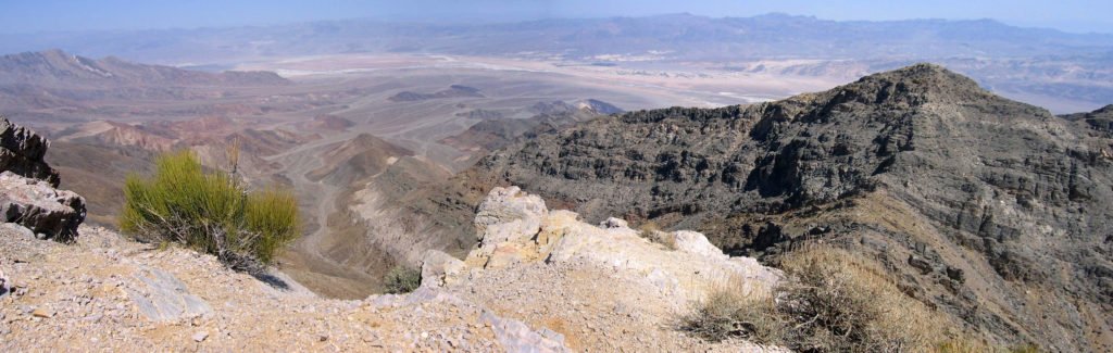
The first thing that comes to mind when thinking about the Death Valley is unbearable heat, aridity and a barren and a boring landscape. After all, Death Valley is the hottest, driest and lowest point in the USA. Why should we recommend a hike in such a wasteland? Simply because Death Valley isn’t just death and actually has a lot to offer. This hike takes you up to an elevation of over 9,000 feet a.s.l. and is therefore recommended during the summer months, when the temperatures below become unbearable. During the winter months, snow and temperatures below freezing are not uncommon.
The goal of the hike is Wildrose Peak, which stands at an elevation of 9,064 feet (2,763 meters) in the Panamint Range and is the second highest point within this mountain range, right after Telescope Peak. And don’t worry, you don’t have to hike all the way up to this elevation.
The hike to the summit is just over 4 miles (6.8 km) long (one way) or 8.4 miles (13.6 km) round trip. You have to climb about 670 metres in altitude.
Where to start? To get to the starting point of the hike, drive west from Stovepipe Wells on California 190. After about 9 miles, turn left onto Emigrant Canyon Road. Follow this road for about 21 miles to Wildrose Campground. Drive another 7 miles from the campground to the car park (you will see signs). The last 4 miles are unpaved. We recommend calling the ranger station ahead about the road condition. After heavy rains, it is advisable to drive with an SUV with high clearance.
From the car park, you will see the signs pointing to Wildrose Peak. The trail itself is well maintained and it is only moderately uphill at first. We did the hike in late summer and there were countless flowers in bloom and a number of beautiful butterflies. You wouldn’t expect so much color in Death Valley.
After about 1 ½ hours, you will have the first views of the valley. The last 30 minutes are a bit steeper, like serpentines. But even this section can absolutely be done by beginners. The total hike up takes about two hours. The way back to the car is the same. Time required approx. 1.45 hours
Hike (part of) the California Mission Trail – Mission San Antonio de Padua
Difficulty: Easy Start/End: Mission San Antonio de Padua | Ascent: Flatland | Distance: Flexible
If you are looking for a great hike that gives you an insight into California’s rich history, this is the ideal hike for you. The entire Camino Real, the California Missions Trail is 600 miles (965 km) long and connects all 21 Spanish missions in California. While hiking the entire trail is most likely a life-changing experience, it is not quite doable in a single day or weekend.
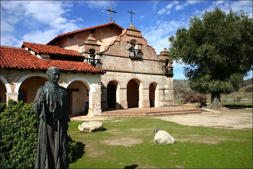
Our trail recommendation leads you to the Mission San Antonio de Padua near King City in Monterey County. This mission is one of the oldest Spanish missions in California and is not inside a city or town in the current day. This makes it ideal to explore the mission and take a relaxing stroll around the area while feeling like a Spanish settler in the 18th century.
The mission itself has been renovated since 2005 and is a great sight. You can park right by the mission and start your hike along the mission road for as far as you like. Close to the entrance, you will find an old Spanish aqueduct used to water the fields of the mission.
A little further down the trail, you will see an old Indian cemetery and a stone threshing floor that the Native Americans used. These sights are a great reminder of the history of the U.S. and California.
The fact that the area is flat and full of interesting and exciting history makes the mission a great stop on a California roadtrip for families.
Crag Lake Trail, Lassen Volcanic National Park from Manzanita Lake
Difficulty: Medium Start/End: Manzanita Lake | Distance: 4 mi (6.4 km) | Duration: 3 hours | Ascent: 900 ft (300 m) m

The starting point for this hike is at Manzanita Lake/Campground in Lassen National Park. The first part of the trail is mostly flat, well-developed and leads through shady forest. Only the last third of the hike is uphill with 900 feet (300 meters) in elevation.
At the end of the trail, you will reach Crag Lake, which is beautifully located in a small valley. According to the ranger, it is possible to jump into the lake. The water is supposed to be healthy, as it contains a number of minerals. But we just put our feet into the water, and it’s far too cold for us. After some relaxation by the lake, you can take the same trail back to the car park, which takes another 1.5 hours.
Gaylor Lakes Hike, Yosemite National Park from Tioga Pass
Difficulty: Easy Start/End: Tioga Pass Entrance | Distance: 2 mi (3.2 km) | Duration: 2 hours | Ascent: 600 ft. (200 m)

The starting point of this hike is at the parking lot of Lee Vining, just right behind the Tioga Pass Entrance. The trail itself starts right at the parking lot. It’s a 2 mile (3.2 km) round trip hike with an elevation of around 600 feet (200 m). The views along the entire hike are incredible, already on the parking lot.
The path is relatively steep with a few stone steps and winds up in serpentines. Is not to be underestimated. But the further up you get, the better the view.
After about 45 minutes, you will reach a ridge. After a few more minutes, you will then already be able to see Middle Gaylor Lake. The hike down to the lake and the views are simply breathtaking.
After relaxing by the lake, you will take the same route back to the parking lot. The total hiking time is about 2 hours. For us, this is one of the best hikes in Yosemite National Park.
Panorama Trail in Yosemite National Park
Difficulty: Medium Start/End: Glacier Point/Vernall Fall | Distance: 8.8 mi (14.2 km) | Duration: 4 hours | Descent: 3,000 ft. (1000 m)
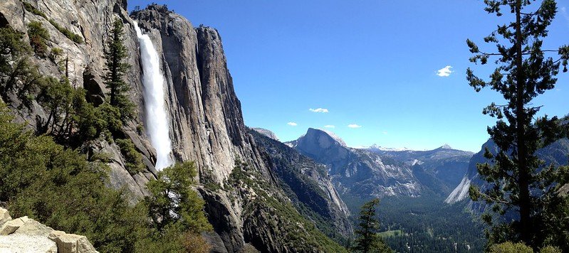
The is a one-way trail that leads from Glacier Point in Yosemite National Park down into the valley and ends at Vernall Fall. From there, you can catch an autobus back to the starting point. The trail is 8.8 mi long (14.2 km) and you will descent almost 3,000 feet (1000 m) back down into the valley.
The path starts at Glacier Point, is moderately steep at the beginning but generally easy to walk. Since it leads downwards, the trail is not recommended if you have problems with your knees. Along the trail, you will always have breathtaking views of Half Dome, Nevada Fall and Vernal Fall.
One of the highlights along the trail is the Panorama Point. It offers some of the best scenic views of the valley. To find it, simply turn left shortly after the Illilouette Falls it. The junction is fairly easy to see and after 150 ft (50 m) you are at the lookout point. But be careful: the lookout point itself has no railing and there is a steep and high cliff. Don’t get too close to the edge.
After enjoying the views, continue the trail for another 5 miles and you will reach the Nevada Falls. The trail reaches the waterfall directly at the point where the water from the falls plunge into the depths. You can admire the incredible forces of nature from a platform. A little bit further back, you can even dip your feet in the water without getting soaked from the falls. An ideal place to take a break.
So far, most of the trail has been rather moderately steep. The next part of 3.8 miles will be steeper. The path now runs right along the waterfall and leads down quite steeply. There are steps, but mind your step, especially after rain.
On your way down, you are rewarded with inredible views of the waterfall. After another 1.3 miles, you will reach Vernall Fall. Here, too, the path leads down very steeply on the left side of the waterfall. Due to the proximity, the steps can get wet and you should be careful where you step. At this part you are also so close to the falls that you might get wet on the way down, depending on the amount of water and direction of the wind. We would recommend to pack a waterproof jacket.
This is a very popular trail and the trail gets quite busy during peak season, especially the last part down to Vernall Falls. Many visitors hike the short distance from the National Park road to Vernall Fall. The last 1.2 miles are more at ground level and lead to the national park road where you can find a bus stop to get back to your starting point.
Conclusion
These are our recommendations for the best hikes in California that will show you the extreme diversity of the state. In the Yosemite National Park, you can enjoy views of some of the greatest waterfalls in the world while you are greeted by a completely different scenery in the Death Valley.
